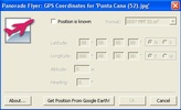
Panorado Flyer is a utility that lets you manually or automatically indicate the exact geographic location in which a photo was taken.
If you know the location data you can enter it manually; if not, you can go to Google Earth to obtain it.
To access the application you only have to select an image on your Windows Explorer and, using your right button, select either the option ’Get location for Google Earth’ or the option ’Edit location manually’.
Once you've entered the geographic location data you can quickly fly over to the place the image was taken in by just selecting the option ’Show location in Google Earth’.
This information will forever be stored on the EXIF header of the digital photograph.


Comments
There are no opinions about Panorado Flyer yet. Be the first! Comment